Trekking Aneto Posets
DISTANCE
87km
ELEVATION
5.840m
It is the great trekking that runs through the two highest peaks of the Pyrenean mountain range. The Aneto with its 3,404 m and the Posets with their 3,375 m they are the two giants of the Pyrenees.
The circuit runs through the heart of the Natural Park discovering the elders glaciers, the spectacular waterfalls, the ibones hidden, the shelters mythical or rivers that disappear ...
When you make your reservation online, you will receive at home the map and the guide with the complete description of each stage.
The giants of the Pyrenees
Trekking Aneto Posets
Personalized attention
It will be a pleasure to help you at all times
Check other services included >
Security
Stay connected to shelters with a station.
very easy to use>
Crampon rental ,ice ax and helmet
Delivery and collection of the material in Renclusa
Availability inquiry >

Do you need help to make your reservation?
Talk to us, we will be happy to help you.
Trekking sections
You can choose the departure shelter and the direction that suits you best. If you want to do any of the proposed variants, you must add a night of refuge for each variant. If you prefer, talk to us.
STAGE 1
Parking Estós-
Renclusa Refuge
Approximate time
5h 15 m / (Option transfer by bus to Llanos Hospital)
Elevation gain +
900 m
Distance
17 km
Elevation loss -
180 m
STAGE 2
Renclusa Refuge - Llauset Refuge
Approximate time
8h 30 m
Elevation gain +
1.150 m
Distance
14,6 km
Elevation loss -
865 m
STAGE 3
Llauset Refuge - Estós Refuge
Approximate time
7h 20 m / 5h 20 m (bus transfer option)
Elevation gain +
990 m
Distance
23,2 km
Elevation loss -
1.465 m
STAGE 4
Estós Refuge - Viadós Refuge
Approximate time
4h 55 m
Elevation gain +
765 m
Distance
11,6 Km
Elevation loss -
925 m
STAGE 5
Viadós refuge - Angel Orús refuge
Approximate time
5h 40 m
Elevation gain +
1.180 m
Distance
11,3 Km
Elevation loss -
800 m
STAGE 6
Angel Orús Refuge - Parking Estós
Approximate time
5h 40 m
Elevation gain +
880 m
Distance
13,1 Km
Elevation loss -
1.100 m
Variant
Aneto Peak
Approximate time
8h 25 m
Elevation gain +
1.405 m
Distance
12,2 km
Elevation loss -
1.405 m
Variant
Peak Posets
Approximate time
6h 50 m
Elevation gain +
2.050 m
Distance
13,69 Km
Elevation loss -
800 m
Variant
Tuca Vallibierna
Approximate time
5h 20 m
Elevation gain +
375 m
Distance
14,7 km
Elevation loss -
1.425 m
Shcedules and prices
Bus Aneto - Besurta
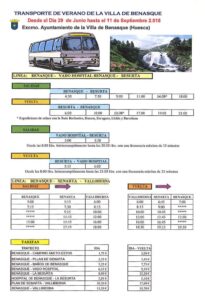
From June 29 to September 11, the bus service from Benasque to La Besurta and vice versa is activated.
Benasque - Besurta
First bus
4:30 A.M
Last bus
16:00p.m
Besurta - Benasque
First bus
6:00 A.M
Last bus
21:00p.m
Biadós Refuge - Angel Orús Refuge
Viadós refuge - detour to Millaris - Collado de la Forqueta - Ibón de Lladaneta - Angel Orús refuge
Distance
11,3 Km
Elevation gain +
1180 m
Elevation loss -
800 m
Approximate time
5h 40 m
The Col de la Forqueta or Eriste (2 864 m), the port mtoThe highest of all that incorporates the circuit, it serves to unite the beautiful valleys of Chistau and L'Aigüand from Grist / Insulation.
We leave from the Viadós refuge (1 760 m) following the GR 11 towards the east, crossing the Viadós huts. After passing the orlast of them, we take the detouríor GR 11.2, descending to the right to cross the ríor Cinqueta from Añes Crossing over a bridge.
It starts like thisí to go up the Ribereta ravine on its right bank, between meadows and a tavern, with pine forests appearing as we approach the Canal de las Tuertas that descends from La Llardaneta, being an area of significant avalanches. Crossing this channel (elevation 2,080 m), a steep climb begins, zigzagging up to the límite of the forest (height 2 240 m, approximately).
Already through the tavern, the road softens. The detour is left on the rightíor to the ibones d'it's Millars yd'Es Leners and you come to the vicinity of a small relief, the Tozal Blanco (2 565 m), located to the right of the path, to which it is advisable to go to get a good viewtomica of the huge ibónd'is Millars (2 353 m).
Back on the trail, continueorto the ascent, reaching a new channel that leaves the Forqueta de Grist pass (2 864 m), between the Posets (N) and Bag massifsMEñola or Eriste (S), and on the dividing line between the Chistau and Benasque valleys. Through a new stony channel we descend towards the Llardaneta lake (2 675 m), with views of the Agujas del Forcau, continuing along the stream that starts from the lake. Soon the ascent to Posets is left on the left and, somewhat mtos forward, the devíor from the GR 11.2 towards Estós, alsoandto the left, arriving shortly at the refuge Angel Orúso El Forcau (2 110 m).
Angel Orús Refuge - Biadós Refuge
Angel Orús Refuge - Ibón de Lladaneta - Collado de la Forqueta - detour to Millaris - Viadós Refuge
Distance
11,3 Km
Elevation gain +
800 m
Elevation loss -
11800 m
Approximate time
5h 25 m
The Col de la Forqueta (2,864 m), the highest pass of all the ones on the circuit, serves to link the beautiful valleys of L'Aigüeta de Grist and Chistau.
From the Ángel Orús refuge (2 148 m), we head northwest along the GR 11.2 trail. The path soon reaches the vicinity of the Llardaneta stream and leaves the GR 11.2 turnoff to the right that goes to Estós. After a while, it crosses the stream and goes up its channel, leaving the route of ascent to Posets on the right (above elevation 2,550 m). From here, the views over the Forcau needles and their vertical strata are magnificent.
After narrowing the channel, we reach the Llardaneta lake (2,675 m), installed in a basin at the foot of the Tuca de la Forqueta (3,011 m) and the Dien Royo. It remains to climb a stony channel to the visible Forqueta de Grist pass (2,864 m), between the Posets (N) and Bagüeñola or Eriste (S) massive.
With magnificent panoramic views, the trace of the trail rushes down a new channel, on the way to the Chistau valley. At elevation 2600 m, pay attention to a small relief, the White tozal (2 565 m), located to the left of the path. It is advisable to go there to see a good panoramic view of the enormous ibón d'es Millars (2 353 m).
Back on the path, increasingly clear, the descent goes into the Ribereta ravine, leaves the access to the ibones d'es Millars and d'es Leners on the left and descends between pine forests that, in more than On one occasion, they are affected by significant landslides that descend from La Llardaneta through the Canal de las Tuertas. Almost at the bottom of the valley, it leads to a track for livestock use and, after crossing a bridge over the Cinqueta de Añes Cruces river, it connects with the GR 11, crossing the Biadós huts and reaching the Biadós refuge ( 1 740 m).
Ángel Orús Refuge - Shelter Estós
Angel Orús refuge - detour to Cdo. of the Fork - each. de la Plana - Ibón Gran de Batisielles - Ibonet de Batisielles - Refuge of Estós
Distance
13,1 m
Elevation gain +
880 m
Elevation loss -
1.100 m
Approximate time
5h 40 m
The route between the two refuges allows the encounter with a fascinating landscape of lakes that mirror under the mass of the Posets or Llardana massif.
From the shelter of Angel Orús (2 110 m), we follow the GR 11.2 towards the northwest, until the crossroads where the path divides towards Viadós and the traditional route of ascent to Posets, on the left, and towards Estós, on the right.
For this orLast route, you cross the Llardaneta stream and, halfway up the slope, you pass by a hut, continuing the climb towards the mouth of the so-called Ibones valley, where the Grist / Eriste lake outlet is installed (2 411 m). From the lake, you climb the steep granite slopes until you reach the Plana lake and the hill of the same name (2,702 m), where you can admire the summit of Llardana or Posets with the remains of its ice cream maker.
The GR 11.2 descends towards Les Basetes, a set of small lakes from where you can get a great view of the Tartera de Perramó lakes and the spiers that delimit the Batisielles circus to the south. The itinerary turns north, leaving the path to said Perramó lakes on the right, to go down a rocky hemicycle, under the fabulous Perramó needles. Reach así the ibones of l'Aigüeta de Batisielles (2 320 m), followed by the lake Gran de Batisielles (2 216 m). We descend until we reach the Ibonet de Batisielles (1 850 m), where the path coming from the Perramó lakes and one that goes down to Estós converge on the right, signposted as S3 by the Posets-Maladeta Natural Park.
It is left behindtos the house near the Ibonet (on the left) and, following the GR 11.2, it gradually turns to the northwest, peeking outtoWe go down slightly, and between meadows and forests, to the border chain that closes Estós to the north. Crossing the Montidiego ravine, in a gentle ascent, you reach a balcony over the valley, from which you go down to cross the river.íor by a lever, going up to the refuge of Estós (1 890 m).
Estós Refuge - Ángel Orús Refuge Refuge
Estós Refuge - Ibonet de Batisielles - Ibón Gran de Batisielles - each. de la Plana - detour to Cdo. of the Fork - Angel Orús Refuge
Distance
13,1 m
Elevation gain +
1.100 m
Elevation loss -
880 m
Approximate time
5h 50 m
The route between the two refuges allows the encounter with a fascinating landscape of lakes that mirror under the mass of the Posets / Llarana massif.
From the Estós refuge (1895 m), the GR 11.2 trail descends to the south, to cross the river that gives it its name with a lever, to begin the ascent up the opposite slope, to a balcony over the valley (1955 m ) that allows you to reach the Batisielles threshold without barely descending.
At the beginning, the path loses a certain height until it crosses the Montidiego ravine, then, again, it regains its height and, between meadows and forests, it looks out over the border chain that closes Estós to the north. Gradually, the route turns and, in a slight descent, enters the Aigüeta de Batisielles basin, crossing a thick pine forest. Reach the hut located next to the Ibonet de Batisielles (1850 m), leaving the turnoff to the Perramó lakes and the S3 path of the Posets-Maladeta Natural Park that comes from the Estós valley to the left, and follow the GR 11.2 signs to go up to the lake Gran de Batisielles (2216 m), which is followed by the lakes of l'Aigüeta de Batisielles (2320 m).
After these, you go over the walls of a rocky hemicycle on the left, under the fabulous Perramó needles, until you reach Les Basetes, a set of small lagoons from where you can get a great view over the Tartera de Perramó lakes and the needles that they delimit the Batisielles cirque to the south.
A last ramp of huge granite blocks leads to the Plana pass (2702 m), where you can discover the summit of Llardana or Posets with the remains of its ice cream maker and, then, to the lake of the same name.
Next, you descend the steep granite slopes to the gutter of the ibón de Grist (2411 m), at the mouth of the so-called valley of the Ibones. After reaching the Llardana cabin and the Llardaneta stream, which will have to be crossed, it connects with the GR 11.2 path that, to the right (E), goes to Biadós and the traditional ascent route of Posets and, towards the left, in a short descent, to the Ángel Orús or El Forcau refuge (2148 m).
Refuge of Estós - Biadós refuge
Estós Refuge - Chistau Port - Pleta d'Añes Cruces - Biadós Refuge
Distance
11,6 Km
Elevation gain +
765 m
Elevation loss -
925 m
Approximate time
4mh 55 m
Stage cltorock of the GR 11 that serves to unite two emblematic valleystoticos of the Aragonese Pyrenees, Estós and Chistau.
We leave the Estós refuge (1 890 m), following the GR 11 route to the west and going up the valley on the left bank, halfway up the hillside. The forest goto staying behindtos as we approach the confluence of the Clarabide ravine (N), which faces the steep Agujas de la Paorl. Aceí we will reach the characterístic «lunch boxes» or fields that, once overcome, leave uston in the Collada de Estós or port of Chistau (2 572 m). An outcrop calctoprisoner on the hill houses a curious «Best» o sump ctorustic that is worth contemplating.
The GR 11 descends decisively, crossing three ravines, until it comes to a place where several streams converge: the Pleta de Añes Cruces, where the itinerary turns in a south-southwest direction, to follow the course of the Cinqueta de Añes Cruces, always on its right bank. Soon you will pass by the hut and source of Puyarueso, through deforested terrain that contrasts with the thick forests of black pine on the other side (Clot pine).
AccompanySurrounded by the view of the impressive mass of Llardana or Posets (3 369 m), to the east, with the remains of a glacier under its summit, we left the límyths of the Posets-Maladeta Natural Park -leaving the detour to the leftíor GR 11.2- and we crossed the set of huts of Viadós / Biadyou, arriving at the refuge of the same name (1 760 m).
Biadós refuge - Refuge of Estós
Refuge of Biadós - Pleta d'Añes Cruces - Port of Chistau - Refuge of Estós
Distance
11,6 Km
Elevation gain +
925 m
Elevation loss -
765 m
Approximate time
5h 05m
Classic stage of the GR 11 that serves to join two emblematic valleys of the Aragonese Pyrenees, that of Chistau and that of Estós.
From the Biadós refuge (1 741 m), take the GR 11 path, which crosses the set of huts of the same name, leaving the GR 11.2 detour on the right and entering the Posets-Maladetas Natural Park. In sight, the impressive mass of Llardana or Posets (3 369 m) stands out, with the remains of a glacier under its summit.
Soon you will pass by the hut and source of Puyarueso, through deforested terrain that contrasts with the thick forests of black pine on the other side (Clot pine). The path gradually goes up the course of the Cinqueta de Añes Cruces, always along its orographic right bank, to the Pleta de Añes Cruces, a place where several streams converge. The GR crosses three ravines and begins to gain height more decisively, towards the important pass of the Chistau pass or Colla d'Estós (2,572 m). A calcareous outcrop in the hill houses a curious 'forau' or karst sinkhole that is worth contemplating.
The descent to the bottom of the Estós valley is very long, crossing at the beginning characteristics 'tarteras' or scree. With its trough or U shape, typical of glacial valleys, on both slopes of the valley, in the middle of the slope, there are shoulder pads that give the complex a particularly photogenic appearance, with a distant backdrop dominated by the massif of the Maladetas. From the confluence with the Clarabide ravine (2 070 m), at the foot of the steep Paúl needles, a path with little slope evolves through the meadows on the left bank of the river, until it reaches the Estós refuge (1 895 m ).
Pico Posets variant
Distance
9,6 Km
Elevation gain +
1.240 m
Elevation loss -
1.240 m
Approximate time
7h 25 m
Between the basins of the Cinca and the ANDwill be, the Posets or Llardana (3 369 m) is the second peak of the Pyrenees, to which some of the glaciers clingtos southern Europe.
From the shelter Angel Orúso El Forcau (2,110 m), take the path to the Viadós refuge (GR 11.2) in a northwesterly direction. After advancing through meadows, granite blocks and some stables, you reach level 2 370 and the crossroads where the GR 11.2 forks: to the right starts the section that goes to Estóyes, throughands of the Col de la Plana, and straight ahead, the one that goes to Viadós continues, by which you must continue.
Shortly afterands, the path crosses the Llardaneta ravine and continues along its left bank to the entrance of the Canal Fonda, open on the southern slope of Posets or Llardana and flanked by the Agujas del Tucón de la Canal (or Dien de Llarana) and the Tucas from the Canal Fonda. A little mtos ahead (2,550 m), leave the GR 11.2 signs to take a marked path that, to the right (N), enters the narrow channel and climbs it until reaching the Col del Diente, often with snow or ice (3,015 m) until well into the summer.
Once we have reached this hill, we just have to continue up the slope (heading north) along the stony Back of Posets, to goto narrowedtoprogressively growing until it becomes a narrow ridge through which we will arrive directly at Posets or Llardana (3 369 m). The return will be doneto by the same itinerary.
Senarta Plan - Renclusa Refuge
Senarta Plan - Benasque Hospital - La Besurta - La Renclusa Refuge
Distance
14 Km
Elevation gain +
1.000 m
Elevation loss -
130 m
Approximate time
5h 40m
Simple stage that runs through the head of the ríor ANDwill be, through a territory where its waters slide through a series of glacial plains, framed by numerous peaks.
In the plains or Plan de Senarta (1 367 m), on the left bank of the small Paso Nuevo reservoir, which at that point dams the waters of the ríor That -picking up tooandn which drains L'Aigüand of Vallibierna-, the GR 11.5 variant is born from the main itinerary of the Pyrenean Path, which joins the Estós and Vallibierna valleys throughands of a small section next to the ANDit will be.
Without abandoning the aforementioned variant, we follow the white and red marks that make us go up the ríor along its left bank, until, after passing by the Fuen de San Farrand, let's cross the shore by the Creg bridgeMEña, to immediately cross the shore again and head up to the Baños de Benasque. With good panortoPlan d'the Bans, you continue on your way, reaching mtos ahead the Hospital de Benasque, next to which you cross the ríor. They line up like thisí the plains of the Hospital parallel to the track that leads to the La Besurta car park. The GR 11.5 crosses the track in Plan d'Its Tton, pass by La Besurta, earn something mtos height on the Pleta l'Anclusa and continueora shortly ascent to the nearby refuge of La Renclusa (2 140 m).
Renclusa Refuge - Llauset Refuge
La Renclusa Refuge - Plan d'Aigüalluts - Ibón de Barrancs - Collado de Salenques - Estany Cap de la Vall - Collada dels Estanyets
Distance
16,6 Km
Elevation gain +
1.270 m
Elevation loss -
865 m
Approximate time
8h 30m
It is one of the stages mtoIt's tough on this great circuit, rewarded by a superb landscape, dominated by the Cursed Mountains and the Aneto peak (3 404 m).
Starting from the La Renclusa refuge (2 140 m), we ascend along the path to Cuello l'Anchor to descend to the Plan Alto d'Aiguallut, where to enjoy the showtoass offered by the waterfall and the «Best» or sinkhole of Aiguallut. We cross the plain by the footbridges that cross several times the ríor, taking the path that, to the right, takes us into the Ball de Barrancs. We will begin to climb this valley, in continuous ascent, through terrain every time mtostandconical, high ridingña, featuring huge granite blocks that mark the access to the Col de Salenques / Col d'Ixalenques (2,808 m), which may require a small climb. To the difficulties of the terrain, jointon the mtoThere are probable incidences of altitude, such as the persistence of snowfields both in shaded areas.ías well as in the final part of the ascent to the hill. The Aneto (3 404 m) stayto at all times to our right.
The GR 11.5 continues downhill through the chaos graníTico, of difíeyelashtorequirement, for the one who alsoandthere will beto to do somethingorn smallor «Climb». At elevation 2,550 m, the route leaves the Salenques / Ixalenques valley to head south to the Cap de la Vall lake, one of the lakes that adorn this stage. Afterands, we will go up the hill at 2 706 m, from where the GR 11.5 descends towards Collada d'the Ponds (2 524 m), linking hereí with the GR 11. We leave the itinerary that goes to Angliós on the left and, on the right, we go towards the Cap de Llauset lake, which we border on its southern end to go over the hill that separates us from the homó refugeyou (2 425 m).
Llauset Refuge - Estós Refuge
Cap de Llauset Refuge - Senarta Plan - Estós Refuge
Distance
23,2 Km
Elevation gain +
990 m
Elevation loss -
1.465 m
Approximate time
7h 20m
We recommend at this stage if the forces are fair, public transport from the Coronas cabin to the Estós Camping. Thus saving 2 hours of travel on foot.
The drop-off times are:
- 10: 00h
- 12: 00h
-16: 00h
- 18: 30h
There is also the possibility of hiring a taxi Tel 628 06 17 37
The Llauset basin and the Vallibierna / Ball de Ballibierna valley are the protagonists of a stage that runs both alongside rocks and lakes and surrounded by forest.
We leave the Cap de Llauset refuge (2 425 m), following the GR 11 towards the north -towards the south is the connecting branch that communicates with the Llauset dam-. Soon, the itinerary turns west to cross the smallor Botorn valleytos and continue to the northwest, along a trough with grass and granite blocks from which the ascent to the Vallibierna / Collada de Ballibierna pass (2 732 m) is faced, where it is possible that someorn snowfield. You now descend towards the Alto de Vallibierna lake (2,475 m), which is followed by the Baixo lake (2,426 m), to the right and left, respectively. At the end of this steep descent you will cross the Llos ravinetos, which converges on that of Vallibierna. The GR 11 crosses the Pleta de Llosas -whose end alsoandn part, to the left, the path to Collada de Culebres and Tuca de Vallibierna (3 056 m)- and continues down the valley.
PrClose to the Coronas refuge, the path that leads to the Coronas lakes starts to the right (N) and ascends to Aneto on its south face. Immediately you reach the Coronas refuge (Les Riberetes) and cross the Coronas bridge, continuing downhill along a track between pine and fir forests. I know passto under the Quillón hut-refuge and, already near the mouth of the valley, take a path to the left to cut off a wide loop of the forest track in the forest of L'Fir tree. About 300 m of steep descent leaves us again on the track and at the Plan de Senarta (1,367 m), near the small Paso Nuevo reservoir, from where the GR 11.5 leaves heading north, to the plains of the Hospital.
Llauset Refuge - Plan Senarta
Cap de Llauset Refuge - Plan of Senarta
Distance
14,7 Km
Elevation gain +
380 m
Elevation loss -
1.425 m
Approximate time
5h 20m
The Llauset basin and the Vallibierna / Ball de Ballibierna valley are the protagonists of a stage that runs both alongside rocks and lakes and surrounded by forest.
We leave the Cap de Llauset refuge (2 425 m), following the GR 11 towards the north -towards the south is the connecting branch that communicates with the Llauset dam-. Soon, the itinerary turns west to cross the smallor Botorn valleytos and continue to the northwest, along a trough with grass and granite blocks from which the ascent to the Vallibierna / Collada de Ballibierna pass (2 732 m) is faced, where it is possible that someorn snowfield. You now descend towards the Alto de Vallibierna lake (2,475 m), which is followed by the Baixo lake (2,426 m), to the right and left, respectively. At the end of this steep descent you will cross the Llos ravinetos, which converges on that of Vallibierna. The GR 11 crosses the Pleta de Llosas -whose end alsoandn part, to the left, the path to Collada de Culebres and Tuca de Vallibierna (3 056 m)- and continues down the valley.
PrClose to the Coronas refuge, the path that leads to the Coronas lakes starts to the right (N) and ascends to Aneto on its south face. Immediately you reach the Coronas refuge (Les Riberetes) and cross the Coronas bridge, continuing downhill along a track between pine and fir forests. I know passto under the Quillón hut-refuge and, already near the mouth of the valley, take a path to the left to cut off a wide loop of the forest track in the forest of L'Fir tree. About 300 m of steep descent leaves us again on the track and at the Plan de Senarta (1,367 m), near the small Paso Nuevo reservoir, from where the GR 11.5 leaves heading north, to the plains of the Hospital.
Llauset Refuge - Estós Refuge
Cap de Llauset Refuge - Senarta Plan - Estós Refuge
Distance
23,2 Km
Elevation gain +
990 m
Elevation loss -
1.465 m
Approximate time
7h 20m
We recommend at this stage if the forces are fair, public transport from the Coronas cabin to the Estós Camping. Thus saving 2 hours of travel on foot.
The drop-off times are:
- 10: 00h
- 12: 00h
-16: 00h
- 18: 30h
There is also the possibility of hiring a taxi Tel 628 06 17 37
The Llauset basin and the Vallibierna / Ball de Ballibierna valley are the protagonists of a stage that runs both alongside rocks and lakes and surrounded by forest.
We leave the Cap de Llauset refuge (2 425 m), following the GR 11 towards the north -towards the south is the connecting branch that communicates with the Llauset dam-. Soon, the itinerary turns west to cross the smallor Botorn valleytos and continue to the northwest, along a trough with grass and granite blocks from which the ascent to the Vallibierna / Collada de Ballibierna pass (2 732 m) is faced, where it is possible that someorn snowfield. You now descend towards the Alto de Vallibierna lake (2,475 m), which is followed by the Baixo lake (2,426 m), to the right and left, respectively. At the end of this steep descent you will cross the Llos ravinetos, which converges on that of Vallibierna. The GR 11 crosses the Pleta de Llosas -whose end alsoandn part, to the left, the path to Collada de Culebres and Tuca de Vallibierna (3 056 m)- and continues down the valley.
PrClose to the Coronas refuge, the path that leads to the Coronas lakes starts to the right (N) and ascends to Aneto on its south face. Immediately you reach the Coronas refuge (Les Riberetes) and cross the Coronas bridge, continuing downhill along a track between pine and fir forests. I know passto under the Quillón hut-refuge and, already near the mouth of the valley, take a path to the left to cut off a wide loop of the forest track in the forest of L'Fir tree. About 300 m of steep descent leaves us again on the track and at the Plan de Senarta (1,367 m), near the small Paso Nuevo reservoir, from where the GR 11.5 leaves heading north, to the plains of the Hospital.
Senarta Plan - Llauset Refuge
Senarta Plan - Bridge crowns - Ibones de Ballibierna - each. Ballibierna - Cap de Llauset Refuge
Distance
14,7 Km
Elevation gain +
1.425 m
Elevation loss -
380 m
Approximate time
6h 00m
The Llauset basin and the Vallibierna / Ball de Ballibierna valley are the protagonists of a stage that runs both alongside rocks and lakes and surrounded by forest.
We leave the Cap de Llauset refuge (2 425 m), following the GR 11 towards the north -towards the south is the connecting branch that communicates with the Llauset dam-. Soon, the itinerary turns west to cross the smallor Botorn valleytos and continue to the northwest, along a trough with grass and granite blocks from which the ascent to the Vallibierna / Collada de Ballibierna pass (2 732 m) is faced, where it is possible that someorn snowfield. You now descend towards the Alto de Vallibierna lake (2,475 m), which is followed by the Baixo lake (2,426 m), to the right and left, respectively. At the end of this steep descent you will cross the Llos ravinetos, which converges on that of Vallibierna. The GR 11 crosses the Pleta de Llosas -whose end alsoandn part, to the left, the path to Collada de Culebres and Tuca de Vallibierna (3 056 m)- and continues down the valley.
PrClose to the Coronas refuge, the path that leads to the Coronas lakes starts to the right (N) and ascends to Aneto on its south face. Immediately you reach the Coronas refuge (Les Riberetes) and cross the Coronas bridge, continuing downhill along a track between pine and fir forests. I know passto under the Quillón hut-refuge and, already near the mouth of the valley, take a path to the left to cut off a wide loop of the forest track in the forest of L'Fir tree. About 300 m of steep descent leaves us again on the track and at the Plan de Senarta (1,367 m), near the small Paso Nuevo reservoir, from where the GR 11.5 leaves heading north, to the plains of the Hospital.
Variant Pico Aneto
Distance
8,25 Km
Elevation gain +
1.410 m
Elevation loss -
1.410 m
Approximate time
8h 25m
Ascentsorn cltothe highest peak in the Pyrenees and the roof of Aragon, the Aneto peak (3 404 m), which requires crossing one of the orlast Pyrenean glaciers and the largest of them.
The traditional ascent to peak mtoThe top of the Pyrenees begins at the La Renclusa refuge (2 140 m), installed in the heart of GR 11.5. From this mountain base, the path looks for the milestones that indicate the lline of ascenton under the Crencha d'els Portillons.
Progressively, it will goto gained height between blocks and granite quarries, passing near the Portillón Lower (2 736 m) -does not cross- and Mas ahead, the Portillón Superior (2 895 m), which is where we will pass to the other side of the mountain. We descend in search of the Aneto glacier, where the slope climbs diagonally to Collada Corones (3 208 m). Walking through the snow or the glacier requires the use of suitable material throughout the year: ice ax, crampons and rope. Once in the hill, where the itinerary that ascends through Coronas joins, the orlast ice of the glacier and the antecima is reached. A orThe last stumbling block separates us from the true peak of Aneto (3 404 m), the Bridge of Muhammad, aandreo and narrow passage between rocks that requires extreme precautions.
The return can be done by the same itinerary or descending directly to look for the Base d'the Salterillo and the bottom of the Barrancs valley, which we will descend to Plan d'Aiguallut, from where, by obvious way, we will return to the La Renclusa refuge.
Variant Tuca Vallibierna
Distance
6,90 m
Elevation gain +
645 m
Elevation loss -
645 m
Approximate time
4h 00m
The ascent to the Tuca de Vallibierna / Ballibierna (3 056 m), by his face mtos accessible, allowto a magnífica view of the Maladetas massif and Aneto peak.
We leave the Cap de Llauset refuge (2 425 m) following the GR 11 to the north -towards the south is the link path that communicates with the Llauset dam-. Soon, the itinerary turns west to cross the smallor Botorn valleytos and continue advancing through a valley until the point where we leave the GR, which continues towards the northwest, in the direction of the Vallibierna pass, while the path of ascension to the Tuca Vallibierna heads southwest, gaining height in the direction of Els Basons. These two small lakes are overcome on their north side, following the milestones that allow us to progress westward through this great terrainíwithout getting lost. In an area mtos flat, over 2 700 m, you have to turn southwest again, to go up the ridge that separates this valley from Llauset. Finally, the toandcimero tail prisoner and, immediately, the point mtos high (3 056 m).
The Vallibierna peak isto formed by two peaks: the Tuca de Vallibierna or Tuca Blanca (3 056 m) and the Tuca de les Culebres (3 051 m), whose spectacular rocky folds give it this name. Between them is the well-known Paso del Caballo, a horizontal stretch of about 30 m, but very toandconvicted on both sides, which, if you want to pass, should be properly secured with a rope and the appropriate material.
The return to the Cap de Llauset refuge is done following the same itinerary.
Schedules and prices Bus Aneto
BENASQUE - HOSPITAL PLAINS - BESURTA
The first bus leaves Benasque in the direction of La Besurta at 4:30 in the morning, having the stop at the door of the Aneto hotels of Benasque. The last bus is at 18:00.
The first bus back, leaves La Besurta at 6:00 and the last one at 21:00
If the schedules that we put below from Benasque do not fit you, remember that you can always go up by car to Llanos del Hospital and leave the car in the parking lot that is before a barrier on the left, because from that point, from the 8:00 and until 20:30They leave for Besurta with a maximum frequency of 35 minutes.
RATES
If you want to leave from Benasque and buy the roundtrip ticket, it will cost you 12,20€. If you go up with your car to the hospital plains and take the bus from there to La Besurta, the round trip will cost you 5,10€.