Trekking Aneto Mulleres
DISTANCE
72km
ELEVATION
5.930m
It is an alpine trek that climbs From 3.000, the Dill, the highest peak of the Pyrenean mountain range with its 3.404 m and the Mulleres with its 3,010m, one of the giants of the Pyrenees in addition to the safeguard 2,750m. You can also do this same route without going up to the peaks.
It is an alpine circuit, that runs through the heart of Natural Park discovering the elders glaciers, the spectacular waterfalls, the ibones hidden, the shelters mythical or rivers that disappear ...
When you make your reservation online, you will receive at home the map and the guide with the complete description of each stage.
The giants of the Pyrenees
Trekking Molieres

Do you need help to make your reservation?
Talk to us, we will be happy to help you.
Personalized attention
It will be a pleasure to help you at all times
Check other services included >
Security
Stay connected to shelters with a station.
very easy to use>
Crampon rental ,ice ax and helmet
Delivery and collection of the material in Renclusa
Availability inquiry >
Stages
This route is indicated for people with some experience in the mountains. To climb to the top of Aneto it is ESSENTIAL to use crampons and ice axes. Being able to leave once the ascent is completed in the Renclusa refuge and pick them up at the end of the trek. They will be used 3 nights, con 4 stages three of them very demanding. If you prefer, speak with us.
STAGE 1
Besurta – Aneto Peak - Renclusa Refuge
Approximate time
8h 25 m
Elevation gain +
1.520 m
Distance
14 km
Elevation loss -
1.270 m
STAGE 2
Renclusa Refuge -
Llauset refuge
Approximate time
8h 30 m
Elevation gain +
1.150 m
Distance
14,6 km
Elevation loss -
865 m
STAGE 3
Llauset refuge – Conangles Refuge
Approximate time
4h 20 m
Elevation gain +
250 m
Distance
10,5 km
Elevation loss -
1.126 m
STAGE 4
Ref Conangles – Pico Women – Ref. Polite
Approximate time
8h 50 m
Elevation gain +
1.560 m
Distance
17 Km
Elevation loss -
1.440m
STAGE 5
Ref Polite – Safeguard Peak – plains
Approximate time
6h 00 m
Elevation gain +
1.330 m
Distance
14 Km
Elevation loss -
1.090m
Shcedules and prices
Bus Aneto - Besurta
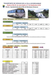
From June 29 to September 11, the bus service from Benasque to La Besurta and vice versa is activated.
Benasque - Besurta
First bus
4:30 A.M
Last bus
16:00p.m
Besurta - Benasque
First bus
6:00 A.M
Last bus
21:00p.m
Besurta – Aneto Peak - Renclusa Refuge
La Besurta – La Renclusa Refuge – Pico Aneto – La Renclusa Refuge
Distance
14 Km
Elevation gain +
1.520 m
Elevation loss -
1.270 m
Approximate time
8h 50m
To carry out this stage it is ESSENTIAL to take the first bus that passes through Llanos del Hospital to La Besurta (leaves Benasque at 4:30). Once in the Besruta we go up to the Renclusa refuge. If we have previously rented the technical material (crampons, piolet, casco) They will have it ready for you and you will only have to take it at this stage, which is when you need it..
The climb to Aneto is divided into three sections,
The first section is up to the Portillón Superior, the path is quite marked, we must think that the first 2 hours we will do them almost at night . The upper part is the Maladeta glacier, so we must have the technical material on hand in case of need.
The second section is where we are surely going to need the technical material as we fully enter the Aneto glacier. A flank to the Ballivierna pass and from there a steep climb up to the pass before the summit.
The third section is the Mohammed Pass, It is essential to have mountain knowledge to face this pass.
The way back is the same, be very careful with the first descent with snow.
If you do not have mountain knowledge, it is recommended to hire a guide from the Benasque Valley.
Renclusa Refuge - Llauset Refuge
La Renclusa Refuge - Plan d'Aigüalluts - Ibón de Barrancs - Collado de Salenques - Estany Cap de la Vall - Collada dels Estanyets
Distance
16,6 Km
Elevation gain +
1.270 m
Elevation loss -
865 m
Approximate time
8h 30m
It is one of the stages mtoIt's tough on this great circuit, rewarded by a superb landscape, dominated by the Cursed Mountains and the Aneto peak (3 404 m).
Starting from the La Renclusa refuge (2 140 m), we ascend along the path to Cuello l'Anchor to descend to the Plan Alto d'Aiguallut, where to enjoy the showtoass offered by the waterfall and the «Best» or sinkhole of Aiguallut. We cross the plain by the footbridges that cross several times the ríor, taking the path that, to the right, takes us into the Ball de Barrancs. We will begin to climb this valley, in continuous ascent, through terrain every time mtostandconical, high ridingña, featuring huge granite blocks that mark the access to the Col de Salenques / Col d'Ixalenques (2,808 m), which may require a small climb. To the difficulties of the terrain, jointon the mtoThere are probable incidences of altitude, such as the persistence of snowfields both in shaded areas.ías well as in the final part of the ascent to the hill. The Aneto (3 404 m) stayto at all times to our right.
The GR 11.5 continues downhill through the chaos graníTico, of difíeyelashtorequirement, for the one who alsoandthere will beto to do somethingorn smallor «Climb». At elevation 2,550 m, the route leaves the Salenques / Ixalenques valley to head south to the Cap de la Vall lake, one of the lakes that adorn this stage. Afterands, we will go up the hill at 2 706 m, from where the GR 11.5 descends towards Collada d'the Ponds (2 524 m), linking hereí with the GR 11. We leave the itinerary that goes to Angliós on the left and, on the right, we go towards the Cap de Llauset lake, which we border on its southern end to go over the hill that separates us from the homó refugeyou (2 425 m).
Llauset refuge – Conangles Refuge
Cap de Llauset Refuge – Conangles Refuge
Distance
10,5 Km
Elevation gain +
250 m
Elevation loss -
1.126 m
Approximate time
4h 20m
Active recovery day after two intense days. Let yourself be seduced by the unknown and beautiful valley of Angilos, your cabin located in a very picturesque place, your lake, its flowers and its impressive views.
We leave the Cap de Llauset refuge (2 425 m), following the GR by itself 11 the day before to Collado Estangets, overcoming here almost all the unevenness of ascent of the day. We continue along the GR11 until the end of the stage. Once at the pass we head east towards Refugio de Conangles. A first hard descent to the plain where the ibón and the Cabaña de Angilos are located, a beautiful print. We continue along smooth terrain until we reach the Angilos ravine and descend sharply along a path that winds along the right side of the ravine., until its confluence with the Salenques river that descends from the hill that bears the same name.
From here a thick forest known as the "obaga de Salenques" ideal to take refuge from the heat, and spend some time among the refreshing pools of the river. The path in this section is winding and easy until the Salenques Bridge. Here we follow the GR11 northbound along the side of the road during 500 meters to the Hospitalet Refuge, We continue along the GR11 along the track and path along the banks of the Noguera Ribagorzana river to the Conangles Refuge.
Conangles Refuge – Artiga de Lin Refuge
Conangles Refuge – Pico Women – Artiga de Lin Refuge
Distance
16Km
Elevation gain +
1.560 m
Elevation loss -
1.440 m
Approximate time
8h 50m
Day to frame, we will go up through the valley of Mulleres to the top of Mulleres (3.010m) and we will go down its northern slope, specifically for the little frequented Valle de la Escaleta, to the Pla d’Aigualluts, a sublime arrival at the refuge climbing the Collado de la Renclusa located at 2,282m and descending to the same refuge.
We leave the Conangles Refuge (1.565m) along a comfortable track and following the GR11 to Espitau de Vielha. Here we leave the GR 11 to our right and we go west through the Valley of Mulleres. First of flat through a flowery valleys. The path narrows and follows the course of the river almost in its entirety, quickly gaining unevenness. The path is marked by milestones and by wooden posts with yellow paint.. We arrive at the Mulleres Refuge, a metal cabin in very good condition that in case of bad weather is a great place to take refuge, It also has an SOS system through a direct channel with the Pompiers d'Aran.
The arrival at the Collado de Mulleres requires some step that must be watched, it is planned to put chains in this section. Once on the hill, the top is on our left. (South West Direction) We climb comfortably up to its 3,010m.
We look for the descent directly from the top looking for milestones heading north to the Ibones de la Escaleta. It is a path that we are discovering as we get closer, always following the course of the river. Once in the Ibón de la Escaleta on our right (It is) we have the Collado de Aranesi. We climb up to the col through some milestones and a very direct descent completely changes the scenery of stones for an incredible meadow, arriving at the Artiga de Lin refuge.
Artiga de Lin Refuge – Safeguard Peak – Hospital Plains
Artiga de Lin Refuge – Safeguard Peak – Hospital Plains
Distance
14Km
Elevation gain +
1.330 m
Elevation loss -
1.090 m
Approximate time
6h 00m
We leave the Artiga de Lin refuge and go up just behind the refuge through a beech forest, We cross a suspension bridge and we leave the forest and follow the river towards the port of La Escaleta. A succession of hills will take us to Puerto de la Picada. Once there we can decide whether to do the Safeguard Peak or not. In case of doing so, we continue flanking from the pass to the Portillón de Benasque. In case of giving up the peak we go down directly to Besurta.
If we decide to do the peak we will go up and down the same itinerary. This peak is not recommended for people who have vertigo, because there is some air passage without technical difficulty. The descent will be made directly to Llanos del Hospital.
Variant Pico Aneto
Distance
8,25 Km
Elevation gain +
1.410 m
Elevation loss -
1.410 m
Approximate time
8h 25m
Ascentsorn cltothe highest peak in the Pyrenees and the roof of Aragon, the Aneto peak (3 404 m), which requires crossing one of the orlast Pyrenean glaciers and the largest of them.
The traditional ascent to peak mtoThe top of the Pyrenees begins at the La Renclusa refuge (2 140 m), installed in the heart of GR 11.5. From this mountain base, the path looks for the milestones that indicate the lline of ascenton under the Crencha d'els Portillons.
Progressively, it will goto gained height between blocks and granite quarries, passing near the Portillón Lower (2 736 m) -does not cross- and Mas ahead, the Portillón Superior (2 895 m), which is where we will pass to the other side of the mountain. We descend in search of the Aneto glacier, where the slope climbs diagonally to Collada Corones (3 208 m). Walking through the snow or the glacier requires the use of suitable material throughout the year: ice ax, crampons and rope. Once in the hill, where the itinerary that ascends through Coronas joins, the orlast ice of the glacier and the antecima is reached. A orThe last stumbling block separates us from the true peak of Aneto (3 404 m), the Bridge of Muhammad, aandreo and narrow passage between rocks that requires extreme precautions.
The return can be done by the same itinerary or descending directly to look for the Base d'the Salterillo and the bottom of the Barrancs valley, which we will descend to Plan d'Aiguallut, from where, by obvious way, we will return to the La Renclusa refuge.
Schedules and prices Bus Aneto
BENASQUE - HOSPITAL PLAINS - BESURTA
The first bus leaves Benasque in the direction of La Besurta at 4:30 in the morning, having the stop at the door of the Aneto hotels of Benasque. The last bus is at 18:00.
The first bus back, leaves La Besurta at 6:00 and the last one at 21:00
If the schedules that we put below from Benasque do not fit you, remember that you can always go up by car to Llanos del Hospital and leave the car in the parking lot that is before a barrier on the left, because from that point, from the 8:00 and until 20:30They leave for Besurta with a maximum frequency of 35 minutes.
RATES
If you want to leave from Benasque and buy the roundtrip ticket, it will cost you 12,20€. If you go up with your car to the hospital plains and take the bus from there to La Besurta, the round trip will cost you 5,10€.
Comments
tadalafil 10 mg cipla
safe cialis online Capnat 500 mg Tablet

Mutfulley pvdoq
dark markets china hitman for hire dark web

cialis safe after stroke
best site to buy cialis online Thanks for this discussion

Mutfulley fhyij
active darknet markets versus project market

sildenafil 20
vietnamese viagra viagra 100 mg discount viagra
